


les trois becs

andrechauvin
User
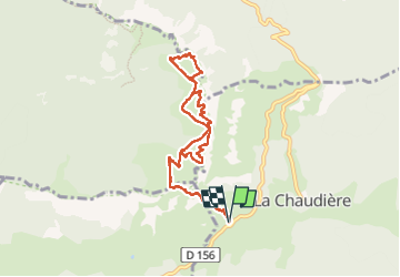

Length
9.5 km

Max alt
1572 m

Uphill gradient
767 m
Km-Effort
19.8 km

Min alt
1036 m

Downhill gradient
769 m
Boucle
Yes
Creation date :
2023-03-09 07:33:40.127
Updated on :
2023-03-09 15:29:17.642
6h00
Difficulty : Difficult

FREE GPS app for hiking
 SityTrail
IGN / Geographical institutes
SityTrail Plus
The world is yours!
About
Trail Walking of 9.5 km to be discovered at Auvergne-Rhône-Alpes, Drôme, La Chaudière. This trail is proposed by andrechauvin.
Description
repérage rando club
Positioning
Country:
France
Region :
Auvergne-Rhône-Alpes
Department/Province :
Drôme
Municipality :
La Chaudière
Location:
Unknown
Start:(Dec)
Start:(UTM)
674878 ; 4944169 (31T) N.
Comments